In the
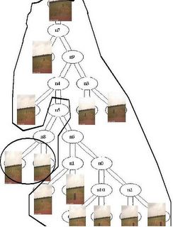
Grand Challenge race, one of our approach to make classification of images for the purpose of road following as well as obstacle avoidance is based on defining some type of distance between drivable and non-drivable scenes. There are many different projection techniques available in the literature. Let us take the example of the "zipping-classifier" mechanism and how we are using it for obstacle avoidance. This technique uses a compressor like Winzip or 7-zip to produce some type of distance between files (here images.) A very nice description of it can be read here. The whole theory is based on Minimum Description Length. An example of a naive classification made on pictures we took at the site visit in San Antonio are shown below. In the interest of reproducibility, we used CompLearn to produce this tree. (
Rudi Cilibrasi is the developer
CompLearn.) The tree clearly allows the segmentation between open areas and the ones with trash cans. We did no processing to the pictures. Obviously, our approach is much more specific in defining this distance between a "good" road and a not-so-good one.

classification of trash can obstacle 
Thank you Cable Kurwitz for providing us with the tree.
More on the rest of our approach can be found
here.


No comments:
Post a Comment