
Subject: Job: Post-doctoral / Internship position in Multiscale/Multirate Image Processing with Applications in the Geosciences
Organization: IFP
Location: Rueil-Malmaison, France
Deadline: Open until filled (beginning 2nd semester 2009)
Duration: 12 months
Gross salary: from ~2400 euros
Context:
IFP has an opening for a post-doctoral position in its Technology, Computer Science and Applied Mathematics Department. IFP is located in Rueil-Malmaison, France, near Paris. The position offers the possibility of collaboration with the Signal and Communications group at University Paris-Est.
IFP is a world-class public-sector research and training center, aimed at developing the technologies and materials of the future in fields of energy, transport and the environment. It provides public and industry stakeholders with innovative solutions for a smooth transition to the more efficient, more economical, cleaner and sustainable energies and materials of the future.
IFP fosters knowledge transfer between long-term fundamental research, applied research and industrial development in keeping with the recommendations of the Barcelona European Council held in March 2002. IFP is funded both by a State budget and by resources provided by private French and foreign international partners.
More information on the Web :
http://www.ifp.fr/
http://www.ifp.com/
http://www-igm.univ-mlv.fr/LabInfo/equipe/signal
http://www-syscom.univ-mlv.fr/~pesquet/
Topic:
The topic proposed for this post-doctoral position is focused on the analysis of geophysical data and their filtering with the help of multiscale/multirate image processing algorithms. Historically, the complexity of seismic data and its interpretation have contributed to the development of several efficient signal processing tools such as the wavelet transform.
In certain seismic data however, different wave types mixed together cannot be separated easily by standard random noise filtering schemes. In order to remedy this issue, efforts have been underway to use models that can be partially matched with data in order to allow for adaptive identification or subtraction.
The aim of the proposed work is to develop innovative techniques for multiscale/ multirate data/model matching. The eventual goal is to exploit simultaneously model and sparse features in the transformed domain with the recently developed directional wavelets and filter banks, based on local multiscale attributes.
While the proposed subject is focused on seismic applications, it is strongly related to more general issues in model based signal processing and detection theory, found in many areas of engineering and science.
Related references:
-C. Chaux et al., 2006, IEEE Trans. Image Processing 15(8) 2397-2412, doi: 10.1109/TIP.2006.875178
Image Analysis Using a Dual-Tree M-Band Wavelet Transform
-A. Droujinine, 2006, J. Geophys. Eng. 3 59-81, doi: 10.1088/1742-2132/3/1/008
Multi-scale geophysical data analysis using the eigenimage discrete wavelet transform
-J. Gauthier et al., 2009, IEEE Trans. Signal Processing, doi: 10.1109/TSP.2009.2023947
Optimization of Synthesis Oversampled Complex Filter Banks
Qualifications:
(1) A PhD degree in Electrical Engineering (signal or image processing,
computer vision, Computer Science, Applied Mathematics), or other related
experience;
(2) Programming skills with MATLAB and C/C++;
(3) Excellent skills in signal/image analysis;
(4) Knowledge in Geophysics is desirable but not required;
(5) Knowledge in wavelets and filter banks is highly desirable.
Application procedure:
Candidates should send an application letter with a PDF detailed CV, together with a list of publications, a PDF copy of their PhD Thesis and at least two reference letters.
Documents should be sent at: laurent(dot)duval(at)ifp.fr
For further information, please contact:
Laurent Duval
IFP, R1130R
1 et 4 avenue de Bois-Preau
F-92852 Rueil-Malmaison Cedex
Tel: +33 1 47 52 61 02
Tel: +33 1 47 52 70 12
Showing posts with label exploration. Show all posts
Showing posts with label exploration. Show all posts
Thursday, August 13, 2009
Post-doctoral / Internship position in Multiscale/Multirate Image Processing with Applications in the Geosciences
Laurent Duval a reader of this blog has a postdoc position (which does not require an understanding of compressive sensing):

Tuesday, September 25, 2007
Don't mess with the Pyramids, people take it personnally

When Michel Barsoum came in town to present his latest findings I was not expecting that it would have any relevancy to an items of my research interest. His presentation was about the process involved in the construction of the Pyramids.
Michel Barsoum and his colleagues have found some evidence that parts of the Great Pyramids of Giza were built using an early form of concrete, debunking an age old myth that they were built using only cut limestone blocks.
The amount of resistance that goes with this theory is pretty impressive. For an idea of the fierceness of the debate, one can read the comments of this blog. As far as I can tell his main interest in the theory stands in the discovery of low cost concrete materials to be used in poor countries. The pyramid story, while interesting on its own right, is clearly setting the stage for more advances in our understanding low cost construction materials.
During the presentation, Michel Barsoum mentioned that if his theory holds, i.e. the upper part of the pyramids are made of concrete, then it is very likely to the top part of the pyramid still hold millions of liters of water. That water would be the reason early electromagnetic measurements were negative.
It so happens that there are other methods that can be used to find out if there is water in rocks:
- Neutron Thermalization is one of them. In neutron transport, it is very well known that neutrons slow down very fast when in contact with water. This is the mechanism at the heart of Pressurized or Boiling Water Reactors (PWR / BWR) in use in most nuclear reactors. So when we try to find water on the Moon
 or Mars, neutrons are generated and scattered through rocks. Detection on how they have been slowed down (this is called thermalization) is key to understand the medium of interest. The idea is that neutrons decelerate to low speed (thermal) very fast when they scatter with hydrogen (because they have about of the same mass). Hydrogen is generally an indicator of water. Neutrons can either be galactic neutrons (very high energy GeV range) or produced by man-made generators (14 MeV) (like in the oil business). In either case the scattering down is so rapid that you don't have any population of neutrons in the intermediate range (epithermal). The technique was used during the Clementine mission to find water on the south pole of the Moon.
 - Another possibility of detecting water is with infra-red. One can take a look at satellite data that have IR sensors such the Hyperion hyperspectral camera on board EO-1. The spectral bands include wavelength in the IR range. One shot of the pyramids can be seen on the side of this paragraph (but if one wants a better one, one can task the satellite for $750 by going through the USGS interface.)

Monday, May 14, 2007
Deep down, Making sense of it all one bit at a time

Last month, Andrew Gould, the CEO of Schlumberger gave a prep talk at an open house.
SCHLUMBERGER OPEN HOUSE
Schlumberger businesses and technologies demonstrations will include subsurface fluid sampling, integrated well completions, robotic tractors in a wellbore, reservoir modeling software, and geophysical seismic exploration.
10:00 a.m. to 4:00 p.m., Zachry Lobby
OPEN PRESENTATION
Andrew Gould
Chairman and CEO, Schlumberger
TITLE: Engineering Challenges (and Successes) in the Search for Oil and Gas
4:00 p.m., Room 102 Zachry
The open presentation attracted a large crowd. During the presentation, I was intrigued by the statement by Andrew that Schlumberger was positioning itself to be a provider of service for Carbon burying technology. But when you think about it, it makes sense as they have devised many services and technologies that are needed for this type of undertaking.
The room was full of people who looked like they wanted to be hired and so it was difficult to have any of them ask questions at the very end of the talk. Pissing off the CEO of the company you want to join, is a very compelling argument to not talk or ask question, or so they believe.... So I ended up having to do the dirty deed, but I was in fact really interested in several answers.
I have mentioned Schlumberger in this blog a while back, it was because of their ability to get signals from 3000 meters underground by using pulsed mud telemetry in the process generally known as Logging While Drilling. The main point was that, in order to save about 200 to 300K$ per day, they had to gather data at the drilling post in real-time so that they could steer the drilling bit (yes, drilling bits can go horizontal). Some people at Sandia have devised a Disposable Fiber Optic Telemetry System but it does not seem to have gain any traction in that industry. Pulsed mud bit rate is equivalent to an astonishing 30 bits per second transmission rate last time I checked. My question to Andrew was: have you guys done better in the past few years ? and the answer looked like a big maybe. He mentioned a new technology that uses some type of radio transmitter between each of the drilling rods but it did not seem to be a system that was yet currently used in the field. The mud communication system is an amazing piece of inventivness and the communication aspect of it is one of the most interesting problem to work on. Because of the very harsh constraints on the system (pressure, temperature,...) I am barely surprised that there isn't a better solution but I also think they should think outside the box on this one. My take would probably include using compressed sensing so that the amount of power generated in the measuring bit can be decreased tremendously. Heat generation (by the computers/electronics of the measuring bit) is non-trivial as there is little in the way of cooling when producing heat in these depths (the soil surrounding the bit is already warmer than the inside). Because of the high temperature environment, one also has to develop some better electronics to deal with these high temperature environment (see Sandia's presentation on electronics development and the need for new technology (SOI))
I then asked a question about the Canadian tar pits and the use of technology such as heat pipe to transfer energy from geothermal wells all the way up to the tar pits in order to warm them up so that they become liquid (i.e. less viscous and therefore more enconomical to retrieve from the ground). The answer looked like there is already have a program called "HTPT" that looks at that. HT may mean high temperature but I am sure what PT stands for.
And then I asked the "forward looking" question: if you wanted to differentiate yourself from your competitors in the next two or three years, where would you put your money in ? The answer was interesting because I was not expecting it. The way I interpreted what he said was: Data fusion, how do you combine the large amount of data produced in the field to have a clearer picture of your oil field (not just in three dimensions but also including time). When I went to talk to each of the engineers present at the different booth after the presentation, it did not seem that they had a view of what that entailed. One of the reasons mentioned was that most customers were not willing to put money into this type of analysis and so the company did not have a specific research team dedicated to that. The company itself is known to be dealing with very large amount of data and making sense of them for their customers. Yet summarizing that knowledge seems to be a difficult undertaking that most customers are only willing to do in-house. I am sure that an enterprising person with views on this issue could help them out. There is no reason to believe that developments in dimensionality reduction in the past few years should not be considered for those gigantic datasets.
Data fusion is also some kind of buzzword, so it may be productive to define what that means. In the measuring bit, there are different kinds of instruments, including neutron generators, radiation detectors, NMR and electromagnetic. Some of the current work seems to have been able to correlate seismic and flow measurements in order to provide a better assessment of the borehole condition. Therefore, a data fusion scheme would be aimed at correlating all the measurements from several types of sensors in order to provide additional information about either the location of the measuring bit and the time dependent geological conditions around that bit.
In order to do that, one has to compare measurements with computations. One of current generic concern is the ability to do inversion with Monte-Carlo codes such as MCNP (This is a very difficult problem because the solving of this inverse problem requires several many runs of forward computation by MCNP) or faster but coarser deterministic methods. You have many different parameters that you change (sensitivity studies) in order to figure out the distribution of parameters for the situation of interest.

Since MCNP or deterministic codes have many different parameters and are running in a finite time, one needs to have tools that provide a way of "interpolating" between parameters family you have not explored computationally. In the end, this problem is not unlike the problem faced in nuclear engineering when one runs a complex thermal hydraulics code: The Experimental Probabilistic Hypersurface tries to help in that respect.
Sunday, February 04, 2007
Finding an item in a bright/dark background
 When one is confronted with images that are very difficult to analyze because the background is very bright or very dark as is usually the case for images taken in space from say star trackers, one should look into using the AVIS FITS viewer. By playing with the lower and upper threshold of the histogram toggle, one can pretty much isolate interesting component that are a little bit above the background.
This is how we evaluated some of the images we gathered from Starnav 1.

After receiving the first images from Starnav 1, we figured that most of the surrounding of the camera was shining too much light into the camera. After going through the AVIS viewer and playing with the filter threshold, we could find other unknown things being in front of that camera (item B and C).

Item B was very difficult to find because it was really only a few pixel above a certain background and one had to remove brighter area around it. Only then, one could see the round shape of it.
Wednesday, January 10, 2007

Thursday, August 25, 2005
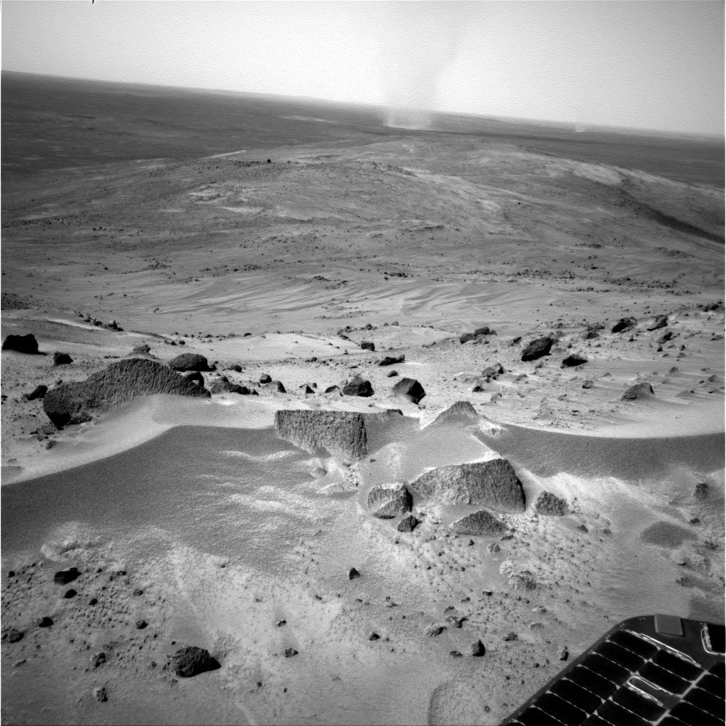
Semantically, there are no F5 tornadoes on Mars.
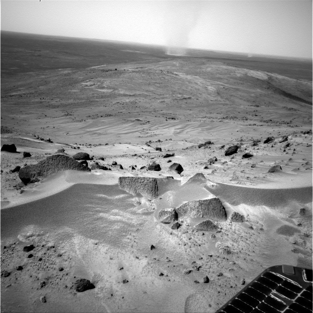
When Mark Lemmon takes pictures of twisters on Mars, he can't really impress his friends because it is unlikely that a dust devil on Mars will ever get to be called a tornado. See, a tornado is defined by the windspeed of its vortex and more importantly by the destruction it could do to habitation. Since no one lives on Mars and the framerate of the Mars Landers camera is low, it is unlikely that we will know the windspeed of these monster dust devils anytime soon.
Sunday, December 19, 2004
The pollution that blinds you
We already knew of the pollution induced smog, a hazy condition produced by particle pollution. We also knew of light pollution due to the atmosphere scattering of city lights and radio FM signals. It used to be that only astronomers were disturbed by this phenomena, but now the RF apectrum is so overwhelmed with new RF sources (cell phones, 802.11...) that it now has an ability to pollute the readings made by meteorology satellites who have intruments that can detect only a few frequency bands.
Thursday, August 05, 2004
Pulsing Mud Communication System

No we are not talking about the deliberate obfuscation of communication of the MUD people in Dilbert's cartoons.
When you are three thousand feet in the ground, the temperature is 200 C, the pressure is 20000 psi and you need to tell people what it is like to be down there. Well this is exactly the problem the folks in oil drilling face everyday. If you consider that drilling cost about 200 to 300 K$ a day, you want to have a better solution than just going ten feet with some pole, pulling it back out, check the soil it witnessed and iterate until you get to 3000 meters down. The solution was devised by Schlumberger as Logging While Drilling (LWD): in short they put a probe next to the drill and expect the probe to send info back up. The probe has nuclear materials, NMR capabilities and so on and it is pretty expensive.

So how do you send information back up from deep down ? Wi-Fi or RF Comms won't work because of the depth of the rock. Resistivity or something equivalent like sound along the poles ? It turns out most of these poles are crunched by the pressure once they are down, so the ideal measurements of conductivity you knew don't work deep into the ground: It is a very bad inverse problem. Schlumberger came up with an innovative means, use the water they send down to help the drill convey messages back to the communication station. When it comes back up, that water is mud. So the probe sends pulses through the water/mud and convey information back up. The data rate is astonishing too: 15 bits/second.
Subscribe to:
Posts (Atom)